Do you want some inspiration for some great New Zealand walks … look no further.
With the days getting longer I thought I would re-post a blog about some of my favourite New Zealand walks around the Central Plateau region in the North Island. While the Tongariro Crossing is touted as one of the best day walks in the world (and it is incredible) there are many others walks in and around Mt Ruapehu and Tongariro.
In addition, here is a link to a really comprehensive list of walks all over New Zealand. I love it because the walks are categorised by duration, from one day to multiple days and the fitness levels are rated from easy, to moderate and challenging.
If you are not sure how to organise one of these walks, give New Zealand Travel Organisers a call and they’ll help you out.
Walking the Central Plateau area
This post is all about the walks in and around the volcanic plateau including Lake Taupo, Mt Ruapehu and Mt Tongariro.

Enjoying the view of the Emerald Lakes on the Tongariro Alpine Crossing
The many magnificent hiking tracks provide spectacular walks for all level of fitness, ranging from multiple days to 30 minutes. I have walked a lot of the tracks but I’ve only really scratched the surface. The local tourist offices, i- sites in Taupo and Turangi can provide a comprehensive list of all the great hiking itineraries.
The Department of Conservation (DOC) is responsible for the maintenance of the tracks. They also produce excellent brochures with detailed instructions about the walks, duration, intensity and more.
The Tongariro Alpine Crossing – 19.4 km, 6-8 hours, moderate level of fitness is required
The Tongariro Alpine Crossing is my favourite but it’s no surprise as it’s rated one of the best day walks in the world. I love it because the terrain is so diverse with tracks passing over volcanic terrain, active volcanos (Mt Tongariro was smoking when I last walked the track) but the pinnacle for me is the famous emerald-coloured lakes.

The only down side is it can be busy in the summer as tourists and locals flock to tick this impressive walk off their bucket lists.

It’s a one-way walk with the crossing beginning and ending at different points so it’s necessary to organise transport but this can easily be done with one of the local shuttle operators.

The colour of the volcanic terrain is breathtaking
The crossing is best hiked in the summer as it can have heavy snowfalls in the winter, however, walkers must be prepared for bad weather at all times. The first time I walked the crossing was in January and despite a good weather forecast, the temperature was 2 degrees at the top. I was extremely pleased I was well prepared with thermals and wet weather gear.
Mt Ruapehu Crater Lake 7- 10 km, 7 hours, a high level of fitness is required

Mt Ruapehu
I did the hike to Mt Ruapehu’s crater lake a couple of summers ago, stating at the top of the Bruce at the Whakapapa ski area. It was a guided walk and I’d suggest you don’t try to do it on your own as there is no formed track and it’s not marked. There are also crevasses where the snow had melting, potentially providing great danger.

Catching the first two chair lifts up Mt Ruapehu makes the walk to the crater lake not so daunting
We caught the first two chair lifts up to give us a head start then trudged through the snow until we got to the crater lake. Full to the brim, it looked as though it was about to burst its banks.
If you are contemplating the walk, read this brochure published by DOC – Know before you go
Taranaki Fall – 6 km loop, 2 hours, moderate fitness required
Just below the visitor’s centre at Whakapapa Village is the beginning of this very picturesque walk. It’s a loop walk with the Taranaki Fall about halfway. The water tumbles 20 metres over the edge of a large lava flow, which erupted from Ruapehu 15,000 years ago, plunging into a boulder-ringed pool, great for a swim on a hot day.
Silica Rapids – 2.5 hr, 7 km return via Bruce Road, moderate fitness required
This walk begins about 250 metres above Whakapapa Visitor Centre and takes you through mountain beech forest alongside a cascading stream, arriving at the creamy-white terraces called the Silica Rapids. The track returns to the Bruce Road 2.5 kilometres above the starting point. There’s a varied range of vegetation and spectacular views of Ruapehu and Ngauruhoe on a clear day.
Tongariro National Trout Centre – 1-2 Km, 30 minute – 1 hour, very easy walk
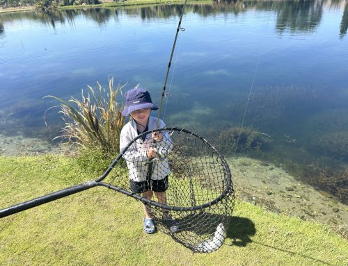
If you have any interest in learning about trout and the management of the Taupo Fishery I can highly recommend a visit to the Tongariro National Trout Centre, just south of Turangi on State Highway 1. There’s a very pleasant walk around the facility down to the Tongariro River. This is where our family had our first taste of fly-fishing and we’ve never looked back. They have a great children’s days several times a year when local volunteer fly-fishermen teach the kids to fish in pools within the Tongariro National Trout Centre.

James caught his first trout, aged six at one of the children’s days at the Tongariro National Trout Centre and has been addicted ever since.
Tokaanu Thermal Walk– 1 km, 30 min, very easy walk
Right behind the Tokaanu Thermal Pools is a short but interesting walk providing a glimpse of the thermal activity in the area. Depending on the level of activity, as it constantly changes, you can see steaming hot mineral pools and bubbling mud among a setting of native bush.
Combine this with a swim in the shared or private natural thermal pools.

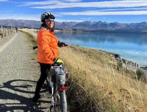
This is the lake reserve in Kuratau – part of the walk from the Kuratau River mouth to Pukawa.
Pukawa to Kuratua River Mouth- 2 hours, 7km, easy walk
The walk starts at the Kuratau River month and is a gentle meander to the Kuratua boat ramp along the reserve and then onto the Omori boat ramp. There is a slight incline, up and over the hill to the Omori Stream and then onto Pukawa through some stunning native bush. The final section to Pukawa is through a stunning stand of native bush.
The residents of Kuratau and Omori have painstakingly spent many years trapping rats, stoats and ferrets and the result is an abundance of birdlife. Bellbirds, Tui and Fantails are plentiful, as well as many other species so take time to listen to the birdsong.
Meads Wall Route – 3 km, 1 hour- moderate fitness required
This walk starts 10 minutes return from the top of the Bruce Road at the Whakapapa Ski fields.
Follow the route to Meads Wall where there is a spectacular rocky outcrop which was one of the filming locations for Lord of the Rings. Meads Wall drops off steeply so be careful while standing on the edge looking northeast at the great views of the valley below and Ngauruhoe.


Leave A Comment